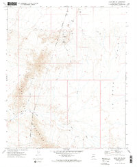
1971 Map of Moon Mtn SE
USGS Topo · Published 1973About this map
The Colorado River Indian Reservation Boundary cuts through this desert landscape in the early 1970s, separating the eastern flats from the rising terrain of the Dome Rock Mountains. This area is defined by its arid hydrology and mining history, with Kaiser Wash and Tyson Wash draining the expansive La Posa Plain. Industrial activity is evident through numerous prospects and specific sites like the Valenzuella Mine, while the isolated Grave south of the mine and the Kaiser Waterhole near Copper Peak highlight the challenges of life and labor in this remote section of La Paz County. The presence of a network of Jeep Trails provides the primary means of navigating between these scattered resource extraction points and the jagged peaks that dominate the western half of the survey.
Find a feature on this map
13 named features on this map. Tap any name to fly to it.
Don’t see what you’re looking for? This feature index may not catch every label — zoom into the map to look around manually.
Map Details
Editions of this 1971 Moon Mtn SE Map
2 editions found
Other maps of this area

1930 · Linskey
USGS Topo · 1:62,500

1931 · Moon Mtn
USGS Topo · 1:62,500

1932 · Moon Mtn
USGS Topo · 1:62,500

1933 · Cunningham Mtn
USGS Topo · 1:48,000

1940 · Dome Rock Mts
USGS Topo · 1:62,500

1942 · Blythe
USGS Topo · 1:250,000

1942 · MOON MTN
USGS Topo · 1:62,500

1954 · Salton Sea
USGS Topo · 1:250,000

1955 · Salton Sea
USGS Topo · 1:250,000
1955 · Moon Mtn
USGS Topo · 1:24,000