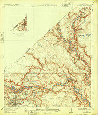
1920 Map of Moonshine Hill
USGS Topo · Published 1932About this map
Moonshine Hill serves as the focal point of this 1916 survey, representing the height of early oil activity in Harris County. The landscape is defined by the winding course of the San Jacinto River and its major tributary, the East Fork San Jacinto River. The intricate drainage system is punctuated by numerous named landmarks such as Cobb Gully, Blackland Gully, and Taylor Gully, which suggest a terrain carved by seasonal waterways and riparian marshlands.
Find a feature on this map
21 named features on this map. Tap any name to fly to it.
Don’t see what you’re looking for? This feature index may not catch every label — zoom into the map to look around manually.
Map Details
Editions of this 1920 Moonshine Hill Map
2 editions found
Other maps of this area

1916 · Crosby
USGS Topo · 1:24,000

1916 · Harmaston
USGS Topo · 1:24,000

1916 · Moonshine Hill
USGS Topo · 1:24,000

1916 · Huffman
USGS Topo · 1:24,000

1916 · Humble
USGS Topo · 1:24,000

1919 · Humble
USGS Topo · 1:31,680

1919 · Weeden
USGS Topo · 1:31,680

1919 · Crosby
USGS Topo · 1:31,680

1920 · Harmaston
USGS Topo · 1:31,680

1920 · Moonshine Hill
USGS Topo · 1:31,680