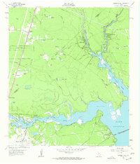
1961 Map of Moonshine Hill
USGS Topo · Published 1962About this map
The confluence of the West Fork San Jacinto River and the East Fork San Jacinto River dominates this early 1960s landscape as they feed into the northern reaches of Lake Houston. The geography reflects a transition from rural timber and oil lands toward suburban development, seen in residential enclaves like Dogwood Acres and Timberlane Acres. Industrial footprints are prominent in the southern portion of the sheet, where the West Riverside Oil Field and scattered Oil Wells indicate the region's energy-driven economy.
Find a feature on this map
66 named features on this map. Tap any name to fly to it.
Don’t see what you’re looking for? This feature index may not catch every label — zoom into the map to look around manually.
Map Details
Editions of this 1961 Moonshine Hill Map
4 editions found
Other maps of this area

1916 · Crosby
USGS Topo · 1:24,000

1916 · Harmaston
USGS Topo · 1:24,000

1916 · Moonshine Hill
USGS Topo · 1:24,000

1916 · Huffman
USGS Topo · 1:24,000

1916 · Humble
USGS Topo · 1:24,000

1919 · Humble
USGS Topo · 1:31,680

1919 · Weeden
USGS Topo · 1:31,680

1919 · Crosby
USGS Topo · 1:31,680

1920 · Harmaston
USGS Topo · 1:31,680

1920 · Moonshine Hill
USGS Topo · 1:31,680