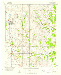
1956 Map of Moore
USGS Topo · Published 1957About this map
Moore anchors the western edge of this mid-century Oklahoma survey, defined by the prominent Atchison Topeka and Santa Fe railroad corridor and a growing network of transportation and leisure facilities. The map captures a unique moment in the area's development, showing a Landing Field and a nearby Race Track just outside the town center. To the east, the landscape transitions into the rolling terrain of the Taylor and Clothier districts, where smaller water features like Kitchen Lake and Mussel Shoals Lake provide focal points for the rural countryside.
Find a feature on this map
24 named features on this map. Tap any name to fly to it.
Don’t see what you’re looking for? This feature index may not catch every label — zoom into the map to look around manually.
Map Details
Editions of this 1956 Moore Map
3 editions found
Other maps of this area

1892 · Moore
USGS Topo · 1:62,500

1893 · Norman
USGS Topo · 1:62,500

1893 · Oklahoma City
USGS Topo · 1:62,500

1898 · Purcell
USGS Topo · 1:125,000

1904 · Chickasha
USGS Topo · 1:125,000

1925 · Norman NO 2
USGS Topo · 1:24,000

1934 · Crutcho Creek
USGS Topo · 1:24,000

1934 · Moore
USGS Topo · 1:62,500

1936 · Norman
USGS Topo · 1:62,500

1938 · Moore
USGS Topo · 1:62,500