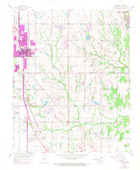
1956 Map of Moore
USGS Topo · Published 1970About this map
The growing community of Moore anchors the western edge of this landscape, situated along the Atchison Topeka and Santa Fe railroad corridor. While the urban core centers on Twelfth Street, the surrounding territory reveals a transition from agricultural land to industrial and infrastructure uses, evidenced by scattered Sandpits, Oil Wells, and the broad expanse of Westheimer Field to the south. Water management and recreation are central themes, dominated by the massive reservoir of Stanley Draper Lake in the northeast and smaller bodies like Kitchen Lake and Mussel Shoals Lake. The topography is defined by the drainage systems of the Little River and the North Fork, which carve through the rural reaches of Taylor and Norman. Smaller landmarks, such as Smith Cem and the settlement of Clothier, offer specific points of interest for genealogists tracing the human geography of Cleveland County during this era of mid-century development.
Find a feature on this map
23 named features on this map. Tap any name to fly to it.
Don’t see what you’re looking for? This feature index may not catch every label — zoom into the map to look around manually.
Map Details
Editions of this 1956 Moore Map
3 editions found
Other maps of this area

1892 · Moore
USGS Topo · 1:62,500

1893 · Norman
USGS Topo · 1:62,500

1893 · Oklahoma City
USGS Topo · 1:62,500

1898 · Purcell
USGS Topo · 1:125,000

1904 · Chickasha
USGS Topo · 1:125,000

1925 · Norman NO 2
USGS Topo · 1:24,000

1934 · Crutcho Creek
USGS Topo · 1:24,000

1934 · Moore
USGS Topo · 1:62,500

1936 · Norman
USGS Topo · 1:62,500

1938 · Moore
USGS Topo · 1:62,500