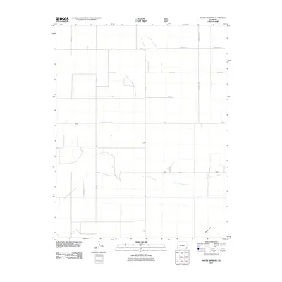
2011 Map of Moore Draw NW
USGS Topo · Published 2011About this map
Rodley Cemetery stands as a quiet focal point in this sparsely populated section of the High Plains, situated north of the North Fork Cimarron River. This 2011 survey illustrates a highly structured landscape defined by an extensive grid of section-line roads, including County Road T and County Road S. The terrain is shaped by the intermittent drainage of Moore Draw, which cuts through the southeastern corner of the quadrangle. The agricultural and ranching character of the region is evident in the precise arrangement of rural infrastructure, where routes like Co Rd 33 and Co Rd 34 provide the primary access to large land tracts. The map documents the enduring ranching layout of the area before modern shifts in land use or consolidation, preserving the locations of remote family and community landmarks.
Find a feature on this map
18 named features on this map. Tap any name to fly to it.
Don’t see what you’re looking for? This feature index may not catch every label — zoom into the map to look around manually.
Map Details
Editions of this 2011 Moore Draw NW Map
This is the sole edition of this map. No revisions or reprints were ever made.
Other maps of this area

1891 · Springfield
USGS Topo · 1:125,000

1892 · Vilas
USGS Topo · 1:125,000

1893 · Springfield
USGS Topo · 1:125,000

1955 · La Junta
USGS Topo · 1:250,000

1958 · La Junta
USGS Topo · 1:250,000

1968 · La Junta
USGS Topo · 1:250,000

1978 · Walsh SE
USGS Topo · 1:24,000
1978 · Moore Draw SW
USGS Topo · 1:24,000

1978 · Moore Draw NE
USGS Topo · 1:24,000

1978 · Campo NE
USGS Topo · 1:24,000