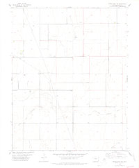
1978 Map of Moore Draw NW
USGS Topo · Published 1979About this map
The North Fork Cimarron River and the Cimarron River converge in this high plains corner of Baca County, defining a landscape of wide drainage basins and sparse water sources. Surveyed in the 1970s, the terrain is marked by an extensive network of wells and several instances of Wells, reflecting the critical importance of groundwater for ranching in this semi-arid region. Human presence is subtle but permanent, characterized by remote landmarks like the Rodley Cem and an isolated Grave located north of the T 32 S township line.
Find a feature on this map
12 named features on this map. Tap any name to fly to it.
Don’t see what you’re looking for? This feature index may not catch every label — zoom into the map to look around manually.
Map Details
Editions of this 1978 Moore Draw NW Map
This is the sole edition of this map. No revisions or reprints were ever made.
Other maps of this area

1891 · Springfield
USGS Topo · 1:125,000

1892 · Vilas
USGS Topo · 1:125,000

1893 · Springfield
USGS Topo · 1:125,000

1955 · La Junta
USGS Topo · 1:250,000

1958 · La Junta
USGS Topo · 1:250,000

1968 · La Junta
USGS Topo · 1:250,000

1978 · Walsh SE
USGS Topo · 1:24,000
1978 · Moore Draw SW
USGS Topo · 1:24,000

1978 · Moore Draw NE
USGS Topo · 1:24,000

1978 · Campo NE
USGS Topo · 1:24,000