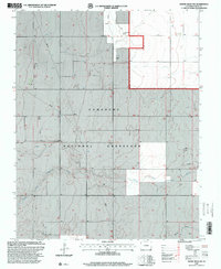
1997 Map of Moore Draw NW
USGS Topo · Published 2000About this map
Comanche National Grassland occupies much of this landscape in southeastern Colorado, where the high plains meet the winding path of the North Fork Cimarron River. The map reveals a sparsely populated ranching and utility corridor, characterized by numerous Wells and a pervasive Pipeline network. Local history is anchored by the Rodley Cem and the named landmark at Wyche, suggesting the importance of early homesteading sites in this arid environment.
Find a feature on this map
11 named features on this map. Tap any name to fly to it.
Don’t see what you’re looking for? This feature index may not catch every label — zoom into the map to look around manually.
Map Details
Editions of this 1997 Moore Draw NW Map
This is the sole edition of this map. No revisions or reprints were ever made.
Other maps of this area

1891 · Springfield
USGS Topo · 1:125,000

1892 · Vilas
USGS Topo · 1:125,000

1893 · Springfield
USGS Topo · 1:125,000

1955 · La Junta
USGS Topo · 1:250,000

1958 · La Junta
USGS Topo · 1:250,000

1968 · La Junta
USGS Topo · 1:250,000

1978 · Walsh SE
USGS Topo · 1:24,000
1978 · Moore Draw SW
USGS Topo · 1:24,000

1978 · Moore Draw NE
USGS Topo · 1:24,000

1978 · Campo NE
USGS Topo · 1:24,000