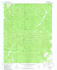
1980 Map of Moore
USGS Topo · Published 1980About this map
Richland Creek and its many tributaries, including Falling Water Creek and Sulphur Creek, carve through this section of the Ozark National Forest along the border of Newton and Searcy Counties. The landscape is defined by isolated peaks and ridges like Bill Hill Peak, Stump Mountain, and Big Middle Ridge, which hem in narrow hollows named for local families, such as Meeks Hollow, Rose Hollow, and Jack Jones Hollow. Small settlements and high-elevation clearings appear at Moore, Dickey Junction, and Iceledo, providing evidence of the remote mountain life in the late 1970s. Local history is anchored by the Hill Cem near Cherry Flat and a Lookout Tower atop Round Hill, while the Richland Recreation Area marks a transition toward public land usage and conservation in the Arkansas highlands.
Find a feature on this map
44 named features on this map. Tap any name to fly to it.
Don’t see what you’re looking for? This feature index may not catch every label — zoom into the map to look around manually.
Map Details
Editions of this 1980 Moore Map
2 editions found
Other maps of this area

1879 · Washington
USGS Topo · 1:62,500

1887 · Smyrna
USGS Topo · 1:62,500

1889 · Treat
USGS Topo · 1:62,500

1889 · Marshall #3
USGS Topo · 1:62,500

1892 · Marshall
USGS Topo · 1:125,000

1894 · Marshall
USGS Topo · 1:125,000

1901 · Marshall
USGS Topo · 1:125,000

1932 · Treat
USGS Topo · 1:62,500

1933 · Mt Judea
USGS Topo · 1:62,500

1934 · Treat
USGS Topo · 1:62,500