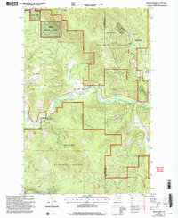
2001 Map of Moose Creek
USGS Topo · Published 2004About this map
The Lincoln Gulch Historical Site preserves the legacy of early mining and settlement along the Blackfoot River in western Montana. This 2001 revision of earlier topography details the transition from industrial extraction to managed conservation within the Helena National Forest. The presence of the Site of Old Lincoln and the nearby Lincoln Gulch Cem offers a specific point of interest for genealogists tracing the roots of early Powell County communities. Across the Lincoln Ranger District, the landscape is defined by its watercourses, from the larger Blackfoot River to smaller tributaries like Sauerkraut Creek and Moose Creek. Mining history is evidenced by the Blackfoot Mine and various excavations, while modern land use is represented by the Blackfoot Canyon Fishing Access along the river banks.
Find a feature on this map
22 named features on this map. Tap any name to fly to it.
Don’t see what you’re looking for? This feature index may not catch every label — zoom into the map to look around manually.
Map Details
Editions of this 2001 Moose Creek Map
This is the sole edition of this map. No revisions or reprints were ever made.
Other maps of this area

1889 · Helena
USGS Topo · 1:250,000

1893 · Helena
USGS Topo · 1:250,000

1899 · Helena
USGS Topo · 1:250,000

1903 · Coopers Lake
USGS Topo · 1:125,000

1903 · Helena
USGS Topo · 1:250,000

1947 · Butte
USGS Topo · 1:250,000

1955 · Choteau
USGS Topo · 1:250,000

1957 · Choteau
USGS Topo · 1:250,000

1958 · Butte
USGS Topo · 1:250,000

1958 · Choteau
USGS Topo · 1:250,000