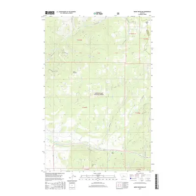
2017 Map of Moose Mountain
USGS Topo · Published 2017About this map
Lewis & Clark National Forest encompasses the high terrain of Meagher and Cascade counties, centered on the prominent peak of Moose Mountain. The landscape is defined by a dense network of watercourses, including Moose Cr, Jumping Cr, and Sheep Cr, which carve through the timbered slopes. In the lower elevations near Green Mtn, the presence of the Holmstrom Ditch indicates the development of water management systems to support the region's agricultural and ranching interests. Forest access is provided by several primitive routes such as Moose Creek Rd and Moose Park Rd, which snake through the drainage basins of Allen Gulch and Coyote Cr. This survey documents a quiet era of federal land management, where high mountain meadows like Moose Park remained largely undisturbed, served only by backcountry roads like Allen Gulch Rd and Jumping Creek Rd.
Find a feature on this map
44 named features on this map. Tap any name to fly to it.
Don’t see what you’re looking for? This feature index may not catch every label — zoom into the map to look around manually.
Map Details
Editions of this 2017 Moose Mountain Map
This is the sole edition of this map. No revisions or reprints were ever made.
Other maps of this area

1886 · Little Belt Mts.
USGS Topo · 1:250,000

1894 · Little Belt Mts.
USGS Topo · 1:250,000

1897 · Little Belt Mts.
USGS Topo · 1:250,000

1898 · Little Belt Mts.
USGS Topo · 1:250,000

1902 · Little Belt Mts.
USGS Topo · 1:250,000

1948 · White Sulphur Springs
USGS Topo · 1:250,000

1958 · White Sulphur Springs
USGS Topo · 1:250,000

1961 · White Sulphur Springs
USGS Topo · 1:250,000
1961 · Kings Hill
USGS Topo · 1:24,000
1961 · Neihart
USGS Topo · 1:24,000