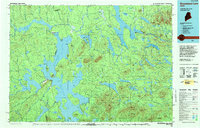
1994 Map of Moosehead Lake
USGS Topo · Published 1994About this map
Moosehead Lake dominates this mid-1990s landscape, serving as the central hub for the Maine North Woods' timber and recreation economy. The map documents a complex network of waterways including Chesuncook Lake, Brassua Lake, and the West Branch Penobscot River. Industrial and logistical infrastructure is marked by the Chesuncook Dam and Ripogenus Dam, which historically managed water for log drives and power.
Find a feature on this map
173 named features on this map. Tap any name to fly to it.
Don’t see what you’re looking for? This feature index may not catch every label — zoom into the map to look around manually.
Map Details
Editions of this 1994 Moosehead Lake Map
This is the sole edition of this map. No revisions or reprints were ever made.
Other maps of this area

1905 · The Forks
USGS Topo · 1:62,500

1907 · The Forks
USGS Topo · 1:62,500

1920 · Moosehead Lake
USGS Topo · 1:62,500

1921 · Brassua Lake
USGS Topo · 1:62,500

1922 · Moosehead Lake
USGS Topo · 1:62,500

1922 · Long Pond
USGS Topo · 1:62,500

1923 · Brassua Lake
USGS Topo · 1:62,500

1924 · Long Pond
USGS Topo · 1:62,500

1925 · Pierce Pond
USGS Topo · 1:48,000

1927 · Pierce Pond
USGS Topo · 1:62,500