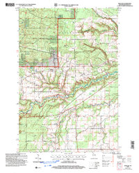
2005 Map of Moquah
USGS Topo · Published 2006About this map
Chequamegon Nicolet National Forest dominates the northwest corner of this quadrangle, managed by the Washburn Ranger District in a region defined by its timber and glacial hydrology. The small settlements of Moquah and Benoit anchor the local community, which is geographically organized into townships like Barksdale, Eileen, and Keystone. The landscape is a network of water and early infrastructure, featuring the winding course of Fish Creek and the Tri-County Recreation Corridor which follows an old railway grade through the center of the sheet. Local landmarks such as the Townhall and St Peters Ch provide specific points of interest for genealogists tracing family roots in this part of Bayfield County. Numerous Gravel Pits and Sandpits scattered across the terrain point to the area's geological history and its continued use for regional materials.
Find a feature on this map
21 named features on this map. Tap any name to fly to it.
Don’t see what you’re looking for? This feature index may not catch every label — zoom into the map to look around manually.
Map Details
Editions of this 2005 Moquah Map
This is the sole edition of this map. No revisions or reprints were ever made.
Other maps of this area

1942 · Ashland
USGS Topo · 1:48,000

1942 · Marengo
USGS Topo · 1:48,000

1944 · Moquah
USGS Topo · 1:48,000

1944 · Grandview
USGS Topo · 1:48,000

1945 · Marengo
USGS Topo · 1:48,000

1947 · Moquah
USGS Topo · 1:48,000

1947 · Ashland
USGS Topo · 1:48,000

1947 · Grandview
USGS Topo · 1:48,000

1953 · Ashland
USGS Topo · 1:250,000

1958 · Ashland
USGS Topo · 1:250,000