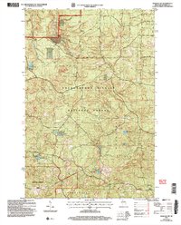
2005 Map of Moquah NW
USGS Topo · Published 2006About this map
The Chequamegon-Nicolet National Forest dominates this landscape in northern Wisconsin, where the topography of the Washburn Ranger District is defined by glacial kettle lakes and sandy barrens. The southern portion of the map highlights the unique ecological character of the Moquah Barrens Area, a pine barrens ecosystem managed within the forest boundaries. Hydrological features are central to this 2005 revision, which tracks the winding course of the East Fork Cranberry River and identifies numerous small water bodies including Sunken Camp Lakes, Lake Lenawee, and Hole Lake. The map includes specific details for local recreation, noting Boat Access (No Ramp) and Boat Access (Carry In) locations, reflecting the era's focus on non-motorized access to these interior waters within the townships of Clover, Bell, and Washburn.
Find a feature on this map
19 named features on this map. Tap any name to fly to it.
Don’t see what you’re looking for? This feature index may not catch every label — zoom into the map to look around manually.
Map Details
Editions of this 2005 Moquah NW Map
This is the sole edition of this map. No revisions or reprints were ever made.
Other maps of this area

1943 · Port Wing
USGS Topo · 1:48,000

1943 · Iron Lake
USGS Topo · 1:48,000

1944 · Moquah
USGS Topo · 1:48,000

1944 · Cornucopia
USGS Topo · 1:48,000

1946 · Cornucopia
USGS Topo · 1:48,000

1946 · Port Wing
USGS Topo · 1:48,000

1947 · Moquah
USGS Topo · 1:48,000

1947 · Iron Lake
USGS Topo · 1:48,000

1953 · Ashland
USGS Topo · 1:250,000

1958 · Ashland
USGS Topo · 1:250,000