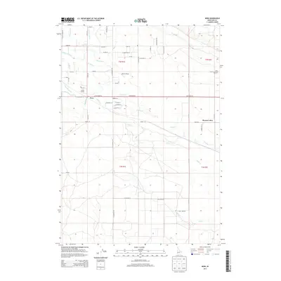
2013 Map of Mora
USGS Topo · Published 2013About this map
The settlement of Mora and the sprawling facility of the Idaho State Correctional Institution anchor this landscape south of Kuna in the early 2010s. The area is defined by a sophisticated water management network, where the New York Canal, Kuna Canal, and Mora Canal weave across the terrain to support local agriculture. This irrigation infrastructure, including the Hubbard Lateral and S Railroad Lateral, transformed the arid high desert into a productive corridor. Small-scale aviation is a distinct characteristic of the region, evidenced by Black's Airfield and Larkin Airport. Natural drainage follows the paths of Indian Cr and Sand Cr, which cut through the township sections. Further east, the community of Pleasant Valley sits amidst a grid of rural roads like Barker Rd and S Cole Rd, illustrating the transition from open range to organized homesteading and institutional use.
Find a feature on this map
56 named features on this map. Tap any name to fly to it.
Don’t see what you’re looking for? This feature index may not catch every label — zoom into the map to look around manually.
Map Details
Editions of this 2013 Mora Map
This is the sole edition of this map. No revisions or reprints were ever made.
Other maps of this area

1892 · Boise
USGS Topo · 1:125,000

1892 · Bisuka
USGS Topo · 1:125,000

1894 · Bisuka
USGS Topo · 1:125,000

1897 · Boise
USGS Topo · 1:125,000

1953 · Cloverdale
USGS Topo · 1:24,000

1953 · Meridian
USGS Topo · 1:24,000

1954 · Boise South
USGS Topo · 1:24,000

1954 · Boise
USGS Topo · 1:62,500

1955 · Christmas Mtn
USGS Topo · 1:24,000
1955 · Coyote Butte
USGS Topo · 1:24,000