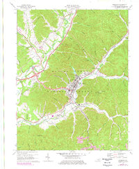
1970 Map of Morehead
USGS Topo · Published 1978About this map
Morehead serves as the central hub of this 1970s topographic study, where the valley of Triplett Creek dictates the path of both the Chesapeake And Ohio railroad and the modern corridor of Interstate 64. The map captures the significant presence of Morehead State University, including the Morehead State University Farm and various gas wells that signal the area's local resource extraction. Beyond the city limits, the landscape transitions into the wooded ridges of the Daniel Boone National Forest, where smaller settlements like Clearfield and Rodburn sit at the mouths of steep hollows.
Find a feature on this map
88 named features on this map. Tap any name to fly to it.
Don’t see what you’re looking for? This feature index may not catch every label — zoom into the map to look around manually.
Map Details
Editions of this 1970 Morehead Map
2 editions found
Other maps of this area

1929 · Morehead
USGS Topo · 1:48,000

1929 · Salt Lick
USGS Topo · 1:62,500

1934 · Salt Lick
USGS Topo · 1:62,500

1935 · Morehead
USGS Topo · 1:62,500

1951 · Soldier
USGS Topo · 1:24,000

1951 · Cranston
USGS Topo · 1:24,000

1951 · Plummers Landing
USGS Topo · 1:24,000

1953 · Haldeman
USGS Topo · 1:24,000

1953 · Farmers
USGS Topo · 1:24,000

1953 · Bangor
USGS Topo · 1:24,000