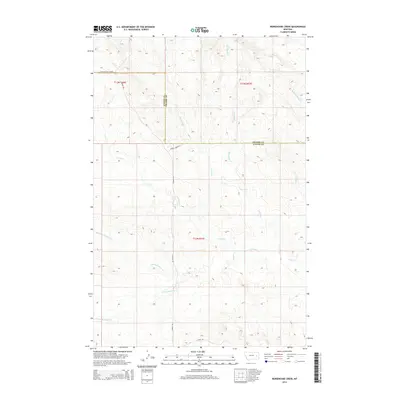
2014 Map of Morehouse Creek
USGS Topo · Published 2014About this map
Custer Creek and its many seasonal tributaries carve through the heart of this landscape, reflecting the intricate drainage patterns of eastern Montana's high plains. The terrain is defined by the winding paths of Morehouse Creek, Physic Creek, and the various branches of Bachelor Creek, including the North Fork Bachelor Creek and South Fork Bachelor Creek. These intermittent waterways provide a detailed look at the local hydrography that historically dictated land use and livestock movement in the region.
Find a feature on this map
18 named features on this map. Tap any name to fly to it.
Don’t see what you’re looking for? This feature index may not catch every label — zoom into the map to look around manually.
Map Details
Editions of this 2014 Morehouse Creek Map
This is the sole edition of this map. No revisions or reprints were ever made.
Other maps of this area

1953 · Miles City
USGS Topo · 1:250,000

1957 · Miles City
USGS Topo · 1:250,000

1958 · Miles City
USGS Topo · 1:250,000

1965 · Little Sheep Mountain
USGS Topo · 1:24,000

1965 · Twin Buttes School
USGS Topo · 1:24,000
1965 · Combs Ranch
USGS Topo · 1:24,000

1965 · Morehouse Creek
USGS Topo · 1:24,000

1969 · Horse Creek Hill
USGS Topo · 1:24,000
1969 · Coal Bank Spring
USGS Topo · 1:24,000
1969 · Kinsey NW
USGS Topo · 1:24,000