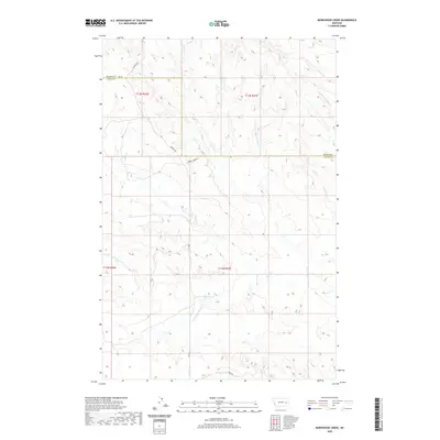
2020 Map of Morehouse Creek
USGS Topo · Published 2020About this map
The boundary between Prairie and Custer counties divides this section of eastern Montana, where a complex network of seasonal drainages carves through the high plains. Waterways such as Custer Creek, Morehouse Creek, and Physic Creek define the local topography, creating a series of ridges and draws characteristic of the region's ranching landscape. The map illustrates a sparse, working landscape where human presence is primarily marked by a grid of rural roads, including Caprock Road and Cherry Creek Road. This modern survey details the hydrological patterns of the Bachelor Creek watershed, showing the intricate split between the North Fork and South Fork Bachelor Creek, which would be essential for anyone tracing land use or historical grazing patterns in this part of the state.
Find a feature on this map
18 named features on this map. Tap any name to fly to it.
Don’t see what you’re looking for? This feature index may not catch every label — zoom into the map to look around manually.
Map Details
Editions of this 2020 Morehouse Creek Map
This is the sole edition of this map. No revisions or reprints were ever made.
Other maps of this area

1953 · Miles City
USGS Topo · 1:250,000

1957 · Miles City
USGS Topo · 1:250,000

1958 · Miles City
USGS Topo · 1:250,000

1965 · Little Sheep Mountain
USGS Topo · 1:24,000

1965 · Twin Buttes School
USGS Topo · 1:24,000
1965 · Combs Ranch
USGS Topo · 1:24,000

1965 · Morehouse Creek
USGS Topo · 1:24,000

1969 · Horse Creek Hill
USGS Topo · 1:24,000
1969 · Coal Bank Spring
USGS Topo · 1:24,000
1969 · Kinsey NW
USGS Topo · 1:24,000