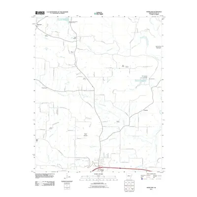
2011 Map of Moreland
USGS Topo · Published 2011About this map
Carrion Crow Mountain rises as a prominent landmark north of Atkins, overlooking a landscape defined by its many small rural settlements and an extensive network of creeks and branches. This part of Pope County is characterized by communities such as Moreland, Oak Grove, and Economy, which are connected by a dense web of local roads like Buttermilk Rd and Mount Vernon Rd. The water management of the era is evident through numerous site reservoirs and dams along Isabell Creek, reflecting local agricultural or flood control needs. For local historians and genealogists, the map provides precise locations for several family and community burial grounds, including the Hudson Cemetery, Sugg Cemetery, and Shiloh Cemetery. The presence of Artesian Spg and features like Burnett Cove highlight the natural hydrology that has long supported these upland Arkansas communities.
Find a feature on this map
101 named features on this map. Tap any name to fly to it.
Don’t see what you’re looking for? This feature index may not catch every label — zoom into the map to look around manually.
Map Details
Editions of this 2011 Moreland Map
This is the sole edition of this map. No revisions or reprints were ever made.
Other maps of this area

1888 · Dardanelle #4
USGS Topo · 1:62,500

1888 · Dardanelle #1
USGS Topo · 1:62,500

1889 · Morrilton No. 3
USGS Topo · 1:62,500

1890 · Dardanelle
USGS Topo · 1:125,000

1892 · Morrillton
USGS Topo · 1:125,000

1894 · Morrillton
USGS Topo · 1:125,000

1956 · Russellville
USGS Topo · 1:250,000

1961 · Morrilton West
USGS Topo · 1:24,000

1961 · Atkins
USGS Topo · 1:24,000
1961 · Dover
USGS Topo · 1:24,000