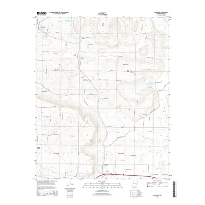
2014 Map of Moreland
USGS Topo · Published 2014About this map
Carrion Crow Mtn and Iron Ore Mtn dominate the landscape of Pope County, where the southern foothills meet the edge of Atkins. This topographic study reveals a rural landscape defined by narrow creek valleys like Burnett Cove and Gum Log Cr. The settlement pattern centers around small communities such as Oak Grove, Economy, and Moreland, where the Moreland Gas Field indicates the region's energy resources. Numerous small burial grounds, including Shiloh Cem, Shady Grove Cem, and Oakland Cem, are situated along historic routes like Ar-105 and Buttermilk RD. The presence of several reservoirs, including the West Fork Point Remove Creek Site 18 Reservoir, highlights modern water management efforts within the traditional creek systems of Isabell Cr and Clear Cr.
Find a feature on this map
107 named features on this map. Tap any name to fly to it.
Don’t see what you’re looking for? This feature index may not catch every label — zoom into the map to look around manually.
Map Details
Editions of this 2014 Moreland Map
This is the sole edition of this map. No revisions or reprints were ever made.
Other maps of this area

1888 · Dardanelle #4
USGS Topo · 1:62,500

1888 · Dardanelle #1
USGS Topo · 1:62,500

1889 · Morrilton No. 3
USGS Topo · 1:62,500

1890 · Dardanelle
USGS Topo · 1:125,000

1892 · Morrillton
USGS Topo · 1:125,000

1894 · Morrillton
USGS Topo · 1:125,000

1956 · Russellville
USGS Topo · 1:250,000

1961 · Morrilton West
USGS Topo · 1:24,000

1961 · Atkins
USGS Topo · 1:24,000
1961 · Dover
USGS Topo · 1:24,000