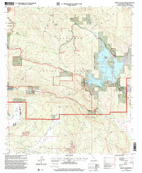
1997 Map of Morena Reservoir
USGS Topo · Published 2000About this map
Lake Morena County Park Reservoir serves as a central landmark for this high-elevation San Diego County landscape, where the waters of Cottonwood Creek and Morena Creek converge. In the late 1990s, the area remained a hub for outdoor recreation and forest management, anchored by Camp Morena and Morena Village. The terrain is defined by protected federal lands, including the Cleveland National Forest, the Hauser Wilderness, and the Pine Creek Wilderness. Significant cultural and topographical markers are found throughout the backcountry, from the Marine Memorial in Hauser Canyon to the Los Pinos Mountain Lookout 4805. Long-distance hikers are represented by the Pacific Crest National Scenic Trail, which winds past Morena Butte and across the Morena Dam Outlet, connecting the southern mountain valleys to the broader Sierra Nevada corridor.
Find a feature on this map
53 named features on this map. Tap any name to fly to it.
Don’t see what you’re looking for? This feature index may not catch every label — zoom into the map to look around manually.
Map Details
Editions of this 1997 Morena Reservoir Map
This is the sole edition of this map. No revisions or reprints were ever made.
Other maps of this area

1903 · Cuyamaca
USGS Topo · 1:125,000

1904 · Southern California Sheet No. 2
USGS Topo · 1:250,000

1931 · Carrizo
USGS Topo · 1:125,000

1939 · Campo
USGS Topo · 1:62,500

1942 · Potrero
USGS Topo · 1:48,000

1942 · Campo
USGS Topo · 1:62,500

1942 · Cuyapaipe
USGS Topo · 1:62,500

1942 · Cuyamaca Peak
USGS Topo · 1:62,500

1944 · Potrero
USGS Topo · 1:62,500

1944 · Cuyamaca Peak
USGS Topo · 1:62,500