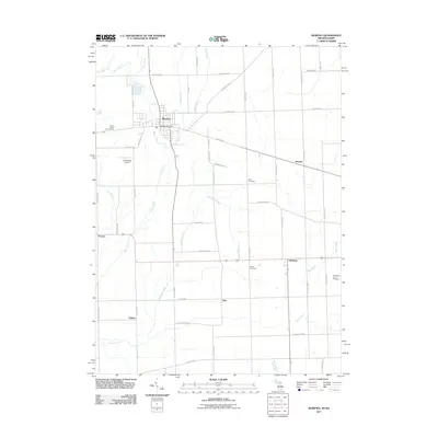
2011 Map of Morenci
USGS Topo · Published 2011About this map
Morenci sits at the northern edge of this agricultural corridor, where the Michigan-Ohio border follows State Line Rd. The landscape is defined by the wandering paths of Bean Creek and its many tributaries, including Silver Creek and the southern stretches of Old Bean Creek. This 2011 survey captures the area's rural character, where small named settlements like Oakshade, Denson, and Thelma anchor a network of county roads. Local landmarks such as the Morenci Post Office and Hochstetler Airport serve as central points for the community. Genealogists will find the locations of Rose Cemetery and Butler Cemetery particularly useful for identifying family sites within this flat, farm-dominated terrain. The map also highlights local industry and recreation at Pennington Farm Orchards and the Green Valley Campground near the village limits.
Find a feature on this map
53 named features on this map. Tap any name to fly to it.
Don’t see what you’re looking for? This feature index may not catch every label — zoom into the map to look around manually.
Map Details
Editions of this 2011 Morenci Map
This is the sole edition of this map. No revisions or reprints were ever made.
Other maps of this area

1911 · Wauseon
USGS Topo · 1:62,500

1913 · Wauseon
USGS Topo · 1:62,500

1913 · Alvordton
USGS Topo · 1:62,500

1943 · Wauseon
USGS Topo · 1:62,500

1944 · Alvordton
USGS Topo · 1:62,500

1953 · Fort Wayne
USGS Topo · 1:250,000

1956 · Fort Wayne
USGS Topo · 1:250,000

1959 · Archbold
USGS Topo · 1:24,000
1960 · Wauseon
USGS Topo · 1:24,000

1960 · Morenci
USGS Topo · 1:24,000