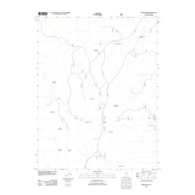
2012 Map of Morey Peak
USGS Topo · Published 2012About this map
Morey occupies the eastern edge of this high-elevation landscape, where the terrain is defined by a series of prominent peaks and ridgelines. The geography is anchored by the massive Morey Peak in the south and extends through the heights of Aspen Peak and Mahogany Peak. This 2012 survey illustrates a remote region where water sources like South Sixmile Canyon Spring and North Sixmile Canyon Spring dictate the local ecology and human access points. Distinctive landforms such as Devils Cave Ridge, Fishhook Ridge, and the Crescent Hogback create a complex topography cut by Luther Waddles Wash. The map also captures several springs scattered across the basins, including Lower Fandango Spring and Sweet Spring, which historically supported movement through these high desert passes.
Find a feature on this map
56 named features on this map. Tap any name to fly to it.
Don’t see what you’re looking for? This feature index may not catch every label — zoom into the map to look around manually.
Map Details
Editions of this 2012 Morey Peak Map
This is the sole edition of this map. No revisions or reprints were ever made.
Other maps of this area

1956 · Tonopah
USGS Topo · 1:250,000

1959 · Tonopah
USGS Topo · 1:250,000

1962 · Tonopah
USGS Topo · 1:250,000

1967 · Moores Station
USGS Topo · 1:62,500

1967 · Upper Fish Lake
USGS Topo · 1:24,000

1967 · Moores Station
USGS Topo · 1:24,000

1967 · Morey Peak
USGS Topo · 1:24,000
1967 · Moores Station SW
USGS Topo · 1:24,000

1968 · Morey Peak
USGS Topo · 1:62,500

1968 · Pritchards Station
USGS Topo · 1:62,500