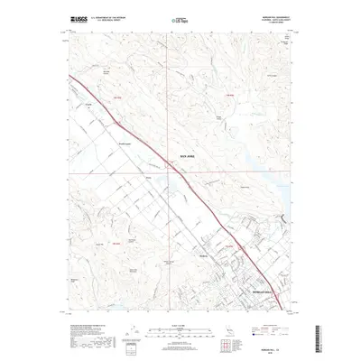
2018 Map of Morgan Hill
USGS Topo · Published 2018About this map
Morgan Hill and the surrounding Santa Clara Valley are depicted here at a point of high density, where the sprawl of San Jose transitions into the foothills of the Diablo Range and the Santa Cruz Mountains. This map captures the complex water management and transport infrastructure essential to the region, including the Santa Clara Conduit and the reservoir at Anderson Lake. The terrain is defined by deep cuts such as Metcalfe Canyon and San Bruno Canyon, which hem in the narrow corridor used by the Monterey Hwy. Between the established centers of Madrone and Coyote, the landscape retains traces of its agricultural past even as suburban development and institutional sites like Gavilan College expand. The drainage of Coyote Creek and Llagas Creek provides a natural framework for the valley floor, contrasting with the steep elevations of Henderson Ridge to the east.
Find a feature on this map
116 named features on this map. Tap any name to fly to it.
Don’t see what you’re looking for? This feature index may not catch every label — zoom into the map to look around manually.
Map Details
Editions of this 2018 Morgan Hill Map
This is the sole edition of this map. No revisions or reprints were ever made.
Other maps of this area

1889 · San Jose
USGS Topo · 1:62,500

1897 · San Jose
USGS Topo · 1:62,500

1897 · Mt. Hamilton
USGS Topo · 1:62,500

1899 · San Jose
USGS Topo · 1:62,500

1916 · New Almaden
USGS Topo · 1:48,000

1917 · Morgan Hill
USGS Topo · 1:62,500

1919 · New Almaden
USGS Topo · 1:62,500

1939 · Morgan Hill
USGS Topo · 1:62,500

1940 · Los Gatos
USGS Topo · 1:62,500

1941 · Morgan Hill
USGS Topo · 1:62,500