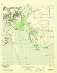
1943 Map of Morgan Point
USGS Topo · Published 1943About this map
Goose Creek, Baytown, and Pelly anchor this coastal landscape during a period of significant industrial and maritime growth along the Cedar Bayou Ship Channel. The map illustrates a complex network of transportation and industry, with both the Southern Pacific and Missouri Pacific railroads serving the urban centers. This 1943 survey documents the shoreline before major later expansions, showing the intricate wetlands of Fisher Marsh and Swan Marsh alongside family-named landmarks like Mesquite Knoll and Evergreen Pt. The boundary between Harris and Chambers counties bisects the area, crossing through tidal waters near Negrohead Lake and Ijams Lake. For genealogists, the Hill of Rest Cem and street-level detail in the northern settlements provide specific points of interest for locating former residences and community landmarks during the war years.
Find a feature on this map
50 named features on this map. Tap any name to fly to it.
Don’t see what you’re looking for? This feature index may not catch every label — zoom into the map to look around manually.
Map Details
Editions of this 1943 Morgan Point Map
This is the sole edition of this map. No revisions or reprints were ever made.
Other maps of this area

1916 · Burnett Bay
USGS Topo · 1:24,000

1916 · Morgan Point
USGS Topo · 1:24,000

1916 · Seabrook
USGS Topo · 1:24,000

1916 · Cedar Bayou
USGS Topo · 1:24,000

1916 · La Porte
USGS Topo · 1:24,000

1919 · Morgan Point
USGS Topo · 1:31,680

1919 · Cedar Bayou
USGS Topo · 1:31,680

1920 · Seabrook
USGS Topo · 1:31,680

1920 · La Porte
USGS Topo · 1:31,680

1920 · Highlands
USGS Topo · 1:31,680