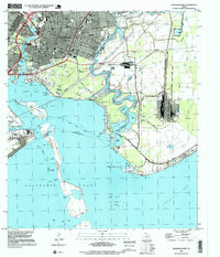
1995 Map of Morgans Point
USGS Topo · Published 1999About this map
Industrial facilities and densely packed neighborhoods define the coastal landscape of Baytown during the mid-1990s. The city's civic and educational infrastructure is clearly visible through a network of local institutions, including Lee College, Lamar Sch, and the Hill of Rest Cem. This era shows a community deeply integrated with the water, where residential streets like Texas Ave and Alexander Drive terminate near the expansive Oil Field and marshlands.
Find a feature on this map
75 named features on this map. Tap any name to fly to it.
Don’t see what you’re looking for? This feature index may not catch every label — zoom into the map to look around manually.
Map Details
Editions of this 1995 Morgans Point Map
This is the sole edition of this map. No revisions or reprints were ever made.
Other maps of this area

1916 · Burnett Bay
USGS Topo · 1:24,000

1916 · Morgan Point
USGS Topo · 1:24,000

1916 · Seabrook
USGS Topo · 1:24,000

1916 · Cedar Bayou
USGS Topo · 1:24,000

1916 · La Porte
USGS Topo · 1:24,000

1919 · Morgan Point
USGS Topo · 1:31,680

1919 · Cedar Bayou
USGS Topo · 1:31,680

1920 · Seabrook
USGS Topo · 1:31,680

1920 · La Porte
USGS Topo · 1:31,680

1920 · Highlands
USGS Topo · 1:31,680