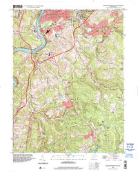
1997 Map of Morgantown South
USGS Topo · Published 2001About this map
Clinton Furnace stands as a prominent historical landmark in the southern reaches of this Monongalia County landscape, reflecting the region's early industrial roots. The topography is defined by the winding corridor of the Monongahela River, where the Monongahela RR follows the western bank through settlements like Uffington and Hilderbrand. To the north, the growing suburbs of Morgantown extend into South Hills and Sabraton, while the surrounding rural areas are dotted with numerous small country congregations including Goshen Ch and Johnson Chapel. Notable heights such as Dorsey Knob and Raven Rock overlook the creek valleys of Booth Creek and Deckers Creek, the latter of which supports the riverside communities of Dellslow and Richard. The map also captures significant local recreational and memorial sites, from Camp Mountaineer in the south to the expansive East Oak Grove Cemetery near the city center.
Find a feature on this map
74 named features on this map. Tap any name to fly to it.
Don’t see what you’re looking for? This feature index may not catch every label — zoom into the map to look around manually.
Map Details
Editions of this 1997 Morgantown South Map
This is the sole edition of this map. No revisions or reprints were ever made.
Other maps of this area

1886 · St. George
USGS Topo · 1:125,000

1891 · St. George
USGS Topo · 1:125,000

1902 · Fairmont
USGS Topo · 1:62,500

1902 · Morgantown
USGS Topo · 1:62,500

1904 · Blacksville
USGS Topo · 1:62,500

1907 · Thornton
USGS Topo · 1:62,500

1923 · Blacksville
USGS Topo · 1:62,500

1923 · Fairmont
USGS Topo · 1:62,500

1925 · Blacksville
USGS Topo · 1:62,500

1925 · Morgantown
USGS Topo · 1:62,500