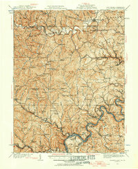
1923 Map of Blacksville
USGS Topo · Published 1956About this map
Dunkard Creek winds across the border between West Virginia and Pennsylvania, anchoring a landscape defined by small hollows and a dense network of early 20th-century rural infrastructure. This area, updated in 1923, shows the intense distribution of local education and faith, with dozens of family and community landmarks like the Stumptown School, Monumental Church, and McCurdyville marking nearly every major creek crossing.
Find a feature on this map
164 named features on this map. Tap any name to fly to it.
Don’t see what you’re looking for? This feature index may not catch every label — zoom into the map to look around manually.
Map Details
Editions of this 1923 Blacksville Map
This is the sole edition of this map. No revisions or reprints were ever made.
Other maps of this area

1886 · St. George
USGS Topo · 1:125,000

1891 · St. George
USGS Topo · 1:125,000

1900 · Masontown
USGS Topo · 1:62,500

1901 · Waynesburg
USGS Topo · 1:62,500
1902 · Clarksburg
USGS Topo · 1:62,500

1902 · Fairmont
USGS Topo · 1:62,500

1902 · Morgantown
USGS Topo · 1:62,500

1903 · Masontown
USGS Topo · 1:62,500

1904 · Blacksville
USGS Topo · 1:62,500

1904 · Waynesburg
USGS Topo · 1:62,500