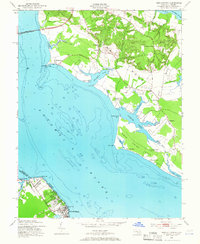
1953 Map of Morgantown
USGS Topo · Published 1966About this map
The Potomac River dominates this mid-century survey, serving as the border between Charles Co, Maryland, and Westmoreland Co, Virginia. On the Maryland shore, the landscape of Swan Point Neck and Cobb Neck is defined by an intricate network of waterways like Cuckold Creek and Piccowaxen Creek. Small communities such as Morgantown and Wayside are connected by rural roads, while landmarks like Old Christ Ch and the Toll House near the Potomac River Bridge reflect the area's social and infrastructure history. Across the water in Virginia, the grid-like streets of Colonial Beach and the nearby Potomac Beach indicate a shift toward more concentrated residential and resort development. This map captures the coastal economy and geography of the lower Potomac just before significant modern expansion, highlighting ferry landings like Wilkerson Wharf and remote outposts like Issue.
Find a feature on this map
55 named features on this map. Tap any name to fly to it.
Don’t see what you’re looking for? This feature index may not catch every label — zoom into the map to look around manually.
Map Details
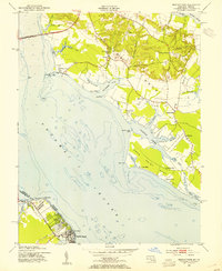
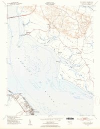
Editions of this 1953 Morgantown Map
3 editions found
Other maps of this area

1889 · Fredericksburg
USGS Topo · 1:125,000

1892 · Fredericksburg
USGS Topo · 1:125,000

1892 · Montross
USGS Topo · 1:62,500

1894 · Wicomico
USGS Topo · 1:62,500

1894 · Fredericksburg
USGS Topo · 1:125,000

1895 · Wicomico
USGS Topo · 1:62,500

1895 · Nomini
USGS Topo · 1:125,000

1895 · Montross
USGS Topo · 1:62,500

1898 · Nomini
USGS Topo · 1:125,000

1902 · Wicomico
USGS Topo · 1:62,500