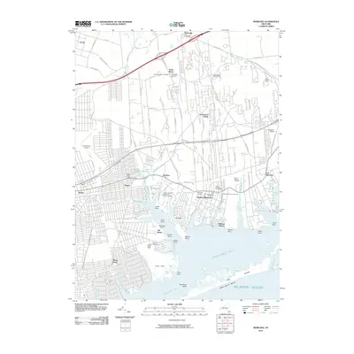
2010 Map of Moriches
USGS Topo · Published 2010About this map
Moriches Bay and the complex estuarine shoreline of Narrow Bay define this South Shore landscape, where countless inlets like Poospatuck Creek and Forge River carve into the mainland. The area serves as a primary gateway to the outer barrier beach, showing Fire Island and Great South Beach protecting the mainland from the Atlantic Ocean. Residential expansion is visible across Mastic Beach, Shirley, and Greenwood Village, yet the map preserves significant historical footprints. Genealogists will find a high density of small family and community burial grounds, such as the William Hawkins and Daniel Downs Cemetery and the Bishop and Robinson Cemetery. Aviation infrastructure is prominent with both Brookhaven Airport and the smaller Spadaro Airport serving the region. The map also delineates the sprawling William Floyd Estate and the Long Island Game Farm, illustrating the mix of protected heritage sites and local attractions.
Find a feature on this map
108 named features on this map. Tap any name to fly to it.
Don’t see what you’re looking for? This feature index may not catch every label — zoom into the map to look around manually.
Map Details
Editions of this 2010 Moriches Map
This is the sole edition of this map. No revisions or reprints were ever made.
Other maps of this area

1903 · Riverhead
USGS Topo · 1:62,500

1904 · Riverhead
USGS Topo · 1:62,500

1904 · Moriches
USGS Topo · 1:62,500

1943 · Riverhead
USGS Topo · 1:62,500

1947 · Bellport
USGS Topo · 1:24,000

1947 · Howells Point
USGS Topo · 1:24,000

1947 · Riverhead
USGS Topo · 1:24,000

1947 · Eastport
USGS Topo · 1:24,000
1947 · Middle Island
USGS Topo · 1:24,000

1949 · New York
USGS Topo · 1:250,000