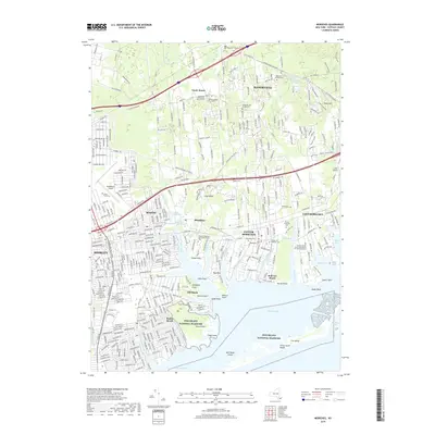
2019 Map of Moriches
USGS Topo · Published 2019About this map
Brookfield Presbyterian Church Cem and several smaller family burial sites like the Wines Private Graveyard anchor the long-settled rural areas north of the coastal developments. The southern shoreline is a complex network of inlets and peninsulas, where the Forge River and Terrell River meet the waters of Moriches Bay. This coastal landscape is dominated by the sprawling communities of Mastic, Shirley, and Center Moriches, which reflect the dense residential growth patterns typical of southern Long Island. Protected lands of the Fire Island National Seashore buffer the mainland from the Atlantic, featuring landmarks like Smiths Point and Great South Beach. Inland, the Manorville Hills and the transit corridors of the Long Island Railroad and Brookhaven Airport define the transition from suburban neighborhoods to the remaining woodland and agricultural spaces near Manorville.
Find a feature on this map
380 named features on this map. Tap any name to fly to it.
Don’t see what you’re looking for? This feature index may not catch every label — zoom into the map to look around manually.
Map Details
Editions of this 2019 Moriches Map
This is the sole edition of this map. No revisions or reprints were ever made.
Other maps of this area

1903 · Riverhead
USGS Topo · 1:62,500

1904 · Riverhead
USGS Topo · 1:62,500

1904 · Moriches
USGS Topo · 1:62,500

1943 · Riverhead
USGS Topo · 1:62,500

1947 · Bellport
USGS Topo · 1:24,000

1947 · Howells Point
USGS Topo · 1:24,000

1947 · Riverhead
USGS Topo · 1:24,000

1947 · Eastport
USGS Topo · 1:24,000
1947 · Middle Island
USGS Topo · 1:24,000

1949 · New York
USGS Topo · 1:250,000