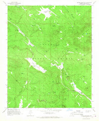
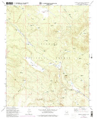
1965 Map of Mormon Mountain
USGS Topo · Published 1967About this map
Coconino National Forest defines the high-country landscape of this mid-1960s survey, dominated by the volcanic profile of Morman Mountain and its surrounding cinder fields. The terrain is marked by a complex network of seasonal water sources and livestock infrastructure, including Bert Lee Tank, Cowboy Tank, and Casner Park Tank, which supported the region's ranching economy. A prominent Industrial Railroad Grade snakes through the topography near Little Horse Park and Bert Lee Park, reflecting the era's timber and resource extraction activities. Landforms like Mt Nestor and T-Six Mountain overlook a series of open parks and deep drainages such as Newman Canyon and Bar M Canyon. The map provides a detailed view of these remote forest lands before modern development, capturing a snapshot of the transition from industrial forest use to recreational management.
Find a feature on this map
64 named features on this map. Tap any name to fly to it.
Don’t see what you’re looking for? This feature index may not catch every label — zoom into the map to look around manually.
Map Details
Editions of this 1965 Mormon Mountain Map
5 editions found
Other maps of this area

1886 · San Francisco Mtns
USGS Topo · 1:250,000

1887 · Verde
USGS Topo · 1:250,000

1891 · San Francisco Mtns
USGS Topo · 1:250,000

1892 · Verde
USGS Topo · 1:250,000

1894 · San Francisco Mtns
USGS Topo · 1:250,000

1899 · San Francisco Mtns
USGS Topo · 1:250,000

1908 · Flagstaff
USGS Topo · 1:125,000

1912 · Flagstaff
USGS Topo · 1:125,000

1923 · Camp Verde
USGS Topo · 1:125,000

1932 · Camp Verde
USGS Topo · 1:125,000