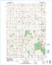
1992 Map of Morrison
USGS Topo · Published 1996About this map
Agricultural lands and rural hamlets define the landscape of south-central Brown County in this early 1990s representation. The town of Morrison serves as a central hub, surrounded by a network of farm roads and small crossroads settlements such as Shirley, Lark, and Wayside. This area is characterized by its drainage patterns, with the Devils River and Branch River cutting through the terrain, and the significant Morrison Swamp occupying the southeast quadrant.
Find a feature on this map
54 named features on this map. Tap any name to fly to it.
Don’t see what you’re looking for? This feature index may not catch every label — zoom into the map to look around manually.
Map Details
Editions of this 1992 Morrison Map
This is the sole edition of this map. No revisions or reprints were ever made.
Other maps of this area

1954 · De Pere
USGS Topo · 1:62,500

1954 · Denmark
USGS Topo · 1:62,500

1954 · De Pere
USGS Topo · 1:24,000

1954 · Chilton
USGS Topo · 1:62,500

1954 · Reedsville
USGS Topo · 1:62,500

1954 · Manitowoc
USGS Topo · 1:250,000

1954 · Bellevue
USGS Topo · 1:24,000

1955 · Green Bay
USGS Topo · 1:250,000

1958 · Manitowoc
USGS Topo · 1:250,000

1974 · Brillion
USGS Topo · 1:24,000