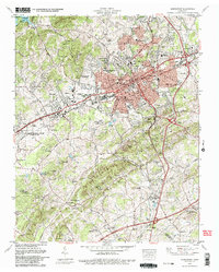
1979 Map of Morristown
USGS Topo · Published 1980About this map
Morristown serves as a regional hub in this late 1970s survey, showing a landscape defined by industrial development, educational expansion, and deep-rooted community sites. The city core, centered on the Courthouse and Library, is surrounded by growing residential neighborhoods like Hillcrest, Dalton Heights, and Emerald Acres. The presence of the State Area Vocational Technical School and Walters State Community College illustrates the era’s focus on regional education and workforce development.
Find a feature on this map
85 named features on this map. Tap any name to fly to it.
Don’t see what you’re looking for? This feature index may not catch every label — zoom into the map to look around manually.
Map Details
Editions of this 1979 Morristown Map
2 editions found
Other maps of this area

1883 · Morristown
USGS Topo · 1:125,000

1893 · Morristown
USGS Topo · 1:125,000

1895 · Morristown
USGS Topo · 1:125,000

1935 · White Pine
USGS Topo · 1:24,000

1935 · Rogersville
USGS Topo · 1:48,000

1935 · Tate Springs
USGS Topo · 1:48,000

1935 · Springvale
USGS Topo · 1:24,000

1935 · Avondale
USGS Topo · 1:24,000

1935 · Morristown
USGS Topo · 1:24,000

1935 · Russellville
USGS Topo · 1:24,000