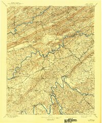
1895 Map of Morristown
USGS Topo · Published 1941About this map
The Morristown rail hub serves as the geographic anchor for this 1890s survey, where the Southern RR and other divisions facilitate the movement of goods and people through East Tennessee. The landscape is defined by the parallel ridges of Clinch Mountain and Copper Ridge, forcing travel through narrow passes like Bean Gap and Notchy Gap. A river-based economy is evident along the Holston River and Nolichucky River, where numerous crossings such as Cloud Ferry, Noe Ferry, and Long Ferry connect isolated settlements like Howard Quarter and Lee Valley to larger market towns. Natural mineral springs are prominent, with Galbraith Sprs and Tate Springs appearing as notable destination points. The map further documents small-scale industry at sites like Turley Mills and Dotson Mill, providing a detailed view of the rural communities and county lines of Hawkins, Hamblen, and Grainger counties during this era.
Find a feature on this map
96 named features on this map. Tap any name to fly to it.
Don’t see what you’re looking for? This feature index may not catch every label — zoom into the map to look around manually.
Map Details
Editions of this 1895 Morristown Map
5 editions found

Other maps of this area

1883 · Morristown
USGS Topo · 1:125,000

1886 · Knoxville
USGS Topo · 1:125,000

1886 · Cumberland Gap
USGS Topo · 1:125,000

1887 · Jonesville
USGS Topo · 1:125,000

1888 · Cumberland Gap
USGS Topo · 1:125,000

1891 · Cumberland Gap
USGS Topo · 1:125,000

1891 · Jonesville
USGS Topo · 1:125,000

1892 · Greeneville
USGS Topo · 1:125,000

1892 · Knoxville
USGS Topo · 1:125,000

1893 · Mt Guyot
USGS Topo · 1:125,000