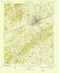
1939 Map of Morristown
USGS Topo · Published 1954About this map
Morristown serves as a bustling rail and road hub in this 1939 field study, situated where the Southern railroad lines intersect near the Andrew Johnson Highway. The landscape is a mix of industrial utility and deep-rooted rural community, featuring the Morristown Water Plant and a sprawling Golf Course alongside numerous family-named landmarks. To the west, Crockett Ridge and Bays Mountain define the horizon, while the lowlands are dotted with small educational and religious centers like McBride Sch and Noe Chapel.
Find a feature on this map
71 named features on this map. Tap any name to fly to it.
Don’t see what you’re looking for? This feature index may not catch every label — zoom into the map to look around manually.
Map Details
Editions of this 1939 Morristown Map
2 editions found
Other maps of this area

1883 · Morristown
USGS Topo · 1:125,000

1893 · Morristown
USGS Topo · 1:125,000

1895 · Morristown
USGS Topo · 1:125,000

1935 · White Pine
USGS Topo · 1:24,000

1935 · Rogersville
USGS Topo · 1:48,000

1935 · Tate Springs
USGS Topo · 1:48,000

1935 · Springvale
USGS Topo · 1:24,000

1935 · Avondale
USGS Topo · 1:24,000

1935 · Morristown
USGS Topo · 1:24,000

1935 · Russellville
USGS Topo · 1:24,000