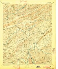
1895 Map of Morristown
USGS Topo · Published 1901About this map
Rogersville and Morristown anchor this late-19th-century landscape, where the ridges and valleys of East Tennessee dictated the path of early commerce and settlement. The map reveals an intricate network of river crossings, including Cloud Ferry and Evans Ferry on the French Broad River, alongside numerous river fords essential for travel before modern bridging. The emergence of the Southern R.R. created new rail hubs like Rogersville Junction and Bull Gap, shifting local industry toward the tracks and away from older river-centered points.
Find a feature on this map
115 named features on this map. Tap any name to fly to it.
Don’t see what you’re looking for? This feature index may not catch every label — zoom into the map to look around manually.
Map Details
Editions of this 1895 Morristown Map
5 editions found

Other maps of this area

1883 · Morristown
USGS Topo · 1:125,000

1886 · Knoxville
USGS Topo · 1:125,000

1886 · Cumberland Gap
USGS Topo · 1:125,000

1887 · Jonesville
USGS Topo · 1:125,000

1888 · Cumberland Gap
USGS Topo · 1:125,000

1891 · Cumberland Gap
USGS Topo · 1:125,000

1891 · Jonesville
USGS Topo · 1:125,000

1892 · Greeneville
USGS Topo · 1:125,000

1892 · Knoxville
USGS Topo · 1:125,000

1893 · Mt Guyot
USGS Topo · 1:125,000