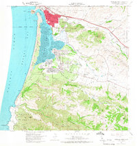
1965 Map of Morro Bay South
USGS Topo · Published 1966About this map
The coastal landscapes of Central California meet the rising Irish Hills in this mid-1960s survey. At the northern edge, the city of Morro Bay is anchored by the massive silhouette of Morro Rock and the extensive Morro Bay State Park, where mudflats and a golf course line the estuary. Further south, the residential grids of Baywood Park, Cuesta-by-the-Sea, and Los Osos reveal a period of suburban expansion into the Los Osos Valley.
Find a feature on this map
54 named features on this map. Tap any name to fly to it.
Don’t see what you’re looking for? This feature index may not catch every label — zoom into the map to look around manually.
Map Details
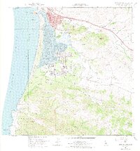
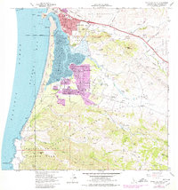
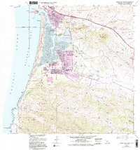
Editions of this 1965 Morro Bay South Map
5 editions found
Historical Maps of Morro Bay Through Time
287 maps found

1897 Port San Luis
San Luis Obispo County, CA

1900 San Luis
San Luis Obispo County, CA

1914 Cholame
San Luis Obispo County, CA

1915 Cholame
San Luis Obispo County, CA

1917 Cholame
San Luis Obispo County, CA

1919 Adelaida
San Luis Obispo County, CA

1919 Paso Robles
San Luis Obispo County, CA

1919 Piedras Blancas
San Luis Obispo County, CA

1922 Pozo
San Luis Obispo County, CA

1927 Piedras Blancas
San Luis Obispo County, CA

1932 Adelaida
San Luis Obispo County, CA

1932 La Panza
San Luis Obispo County, CA

1935 La Panza
San Luis Obispo County, CA

1936 La Panza
San Luis Obispo County, CA

1937 Branch Mtn
San Luis Obispo County, CA

1941 Caliente Mountain
San Luis Obispo County, CA

1941 Port San Luis
San Luis Obispo County, CA

1942 Adelaida
San Luis Obispo County, CA

1942 Branch Mtn
San Luis Obispo County, CA

1942 Caliente Mtn
San Luis Obispo County, CA

1942 East of Cuyama Ranch
San Luis Obispo County, CA

1943 Annette
San Luis Obispo County, CA

1943 Caliente Mtn.
San Luis Obispo County, CA

1943 Cholame
San Luis Obispo County, CA

1943 Commatti Canyon
San Luis Obispo County, CA

1943 Grant Lake
San Luis Obispo County, CA

1943 Paso Robles
San Luis Obispo County, CA

1943 Shedd Canyon
San Luis Obispo County, CA

1944 East of Cuyama Ranch
San Luis Obispo County, CA

1944 Elkhorn Hills
San Luis Obispo County, CA

1944 Midway Peak SW
San Luis Obispo County, CA

1944 Panorama Hills
San Luis Obispo County, CA

1945 Port San Luis
San Luis Obispo County, CA

1947 Adelaida
San Luis Obispo County, CA

1948 Adelaida
San Luis Obispo County, CA

1948 Cypress Mountain
San Luis Obispo County, CA

1948 Estrella
San Luis Obispo County, CA

1948 Lime Mountain
San Luis Obispo County, CA

1948 Paso Robles
San Luis Obispo County, CA

1948 Paso Robles
San Luis Obispo County, CA

1948 York Mountain
San Luis Obispo County, CA

1951 Port San Luis
San Luis Obispo County, CA

1952 Branch Mtn
San Luis Obispo County, CA

1952 Caliente Mountain
San Luis Obispo County, CA

1952 La Panza
San Luis Obispo County, CA

1952 Pozo
San Luis Obispo County, CA

1954 Elkhorn Hills
San Luis Obispo County, CA

1954 Panorama Hills
San Luis Obispo County, CA

1954 Wells Ranch
San Luis Obispo County, CA

1959 Caliente Mountain
San Luis Obispo County, CA

1959 Caliente Mtn
San Luis Obispo County, CA

1959 Chimineas Ranch
San Luis Obispo County, CA

1959 Painted Rock
San Luis Obispo County, CA

1959 Pebblestone Shut-In
San Luis Obispo County, CA

1959 Pico Creek
San Luis Obispo County, CA

1959 Piedras Blancas
San Luis Obispo County, CA

1959 Piedras Blancas
San Luis Obispo County, CA

1959 Simmler
San Luis Obispo County, CA

1959 Taylor Canyon
San Luis Obispo County, CA

1961 Adelaida
San Luis Obispo County, CA

1961 Camatta Canyon
San Luis Obispo County, CA

1961 Cholame
San Luis Obispo County, CA

1961 Holland Canyon
San Luis Obispo County, CA

1961 Orchard Peak
San Luis Obispo County, CA

1961 Paso Robles
San Luis Obispo County, CA

1961 Shedd Canyon
San Luis Obispo County, CA

1962 Caliente Mtn
San Luis Obispo County, CA

1965 Arroyo Grande NE
San Luis Obispo County, CA

1965 Lopez Mountain
San Luis Obispo County, CA

1965 Morro Bay North
San Luis Obispo County, CA

1965 Morro Bay South
San Luis Obispo County, CA

1965 Port San Luis
San Luis Obispo County, CA

1966 California Valley
San Luis Obispo County, CA

1966 Camatta Ranch
San Luis Obispo County, CA

1966 La Panza NE
San Luis Obispo County, CA

1966 La Panza Ranch
San Luis Obispo County, CA

1966 Wilson Corner
San Luis Obispo County, CA

1967 Branch Mtn
San Luis Obispo County, CA

1967 Caldwell Mesa
San Luis Obispo County, CA

1967 Chimney Canyon
San Luis Obispo County, CA

1967 Huasna Peak
San Luis Obispo County, CA

1967 La Panza
San Luis Obispo County, CA

1967 Los Machos Hills
San Luis Obispo County, CA

1967 Pozo Summit
San Luis Obispo County, CA

1967 Santa Margarita Lake
San Luis Obispo County, CA

1967 Tar Spring Ridge
San Luis Obispo County, CA

1977 Caliente Mtn
San Luis Obispo County, CA

1977 Chimney Canyon
San Luis Obispo County, CA

1983 Point Estero
San Luis Obispo County, CA

1989 Paso Robles
San Luis Obispo County, CA

1995 Arroyo Grande NE
San Luis Obispo County, CA

1995 Branch Mountain
San Luis Obispo County, CA

1995 Caldwell Mesa
San Luis Obispo County, CA

1995 Camatta Ranch
San Luis Obispo County, CA

1995 Chimineas Ranch
San Luis Obispo County, CA

1995 Chimney Canyon
San Luis Obispo County, CA

1995 Huasna Peak
San Luis Obispo County, CA

1995 La Panza Ranch
San Luis Obispo County, CA

1995 La Panza
San Luis Obispo County, CA

1995 Lopez Mountain
San Luis Obispo County, CA

1995 Los Machos Hills
San Luis Obispo County, CA

1995 Morro Bay North
San Luis Obispo County, CA

1995 Pozo Summit
San Luis Obispo County, CA

1995 Santa Margarita Lake
San Luis Obispo County, CA

1995 Tar Spring Ridge
San Luis Obispo County, CA

1995 Taylor Canyon
San Luis Obispo County, CA

1995 Wilson Corner
San Luis Obispo County, CA

2012 Adelaida
San Luis Obispo County, CA

2012 Arroyo Grande NE
San Luis Obispo County, CA

2012 Branch Mountain
San Luis Obispo County, CA

2012 Caldwell Mesa
San Luis Obispo County, CA

2012 Caliente Mountain
San Luis Obispo County, CA

2012 California Valley
San Luis Obispo County, CA

2012 Camatta Canyon
San Luis Obispo County, CA

2012 Camatta Ranch
San Luis Obispo County, CA

2012 Cayucos OE W
San Luis Obispo County, CA

2012 Chimineas Ranch
San Luis Obispo County, CA

2012 Chimney Canyon
San Luis Obispo County, CA

2012 Cholame
San Luis Obispo County, CA

2012 Cypress Mountain
San Luis Obispo County, CA

2012 Elkhorn Hills
San Luis Obispo County, CA

2012 Estrella
San Luis Obispo County, CA

2012 Holland Canyon
San Luis Obispo County, CA

2012 Huasna Peak
San Luis Obispo County, CA

2012 La Panza NE
San Luis Obispo County, CA

2012 La Panza Ranch
San Luis Obispo County, CA

2012 La Panza
San Luis Obispo County, CA

2012 Lime Mountain
San Luis Obispo County, CA

2012 Lopez Mountain
San Luis Obispo County, CA

2012 Los Machos Hills
San Luis Obispo County, CA

2012 Morro Bay North
San Luis Obispo County, CA

2012 Morro Bay South OE W
San Luis Obispo County, CA

2012 Morro Bay South
San Luis Obispo County, CA

2012 Oceano OE W
San Luis Obispo County, CA

2012 Orchard Peak
San Luis Obispo County, CA

2012 Painted Rock
San Luis Obispo County, CA

2012 Panorama Hills
San Luis Obispo County, CA

2012 Paso Robles
San Luis Obispo County, CA

2012 Pebblestone Shut-in
San Luis Obispo County, CA

2012 Pico Creek
San Luis Obispo County, CA

2012 Piedras Blancas
San Luis Obispo County, CA

2012 Port San Luis OE W
San Luis Obispo County, CA

2012 Port San Luis
San Luis Obispo County, CA

2012 Pozo Summit
San Luis Obispo County, CA

2012 Santa Margarita Lake
San Luis Obispo County, CA

2012 Shedd Canyon
San Luis Obispo County, CA

2012 Simmler
San Luis Obispo County, CA

2012 Tar Spring Ridge
San Luis Obispo County, CA

2012 Taylor Canyon
San Luis Obispo County, CA

2012 Wells Ranch
San Luis Obispo County, CA

2012 Wilson Corner
San Luis Obispo County, CA

2012 York Mountain
San Luis Obispo County, CA

2015 Adelaida
San Luis Obispo County, CA

2015 Arroyo Grande NE
San Luis Obispo County, CA

2015 Branch Mountain
San Luis Obispo County, CA

2015 Caldwell Mesa
San Luis Obispo County, CA

2015 Caliente Mountain
San Luis Obispo County, CA

2015 California Valley
San Luis Obispo County, CA

2015 Camatta Canyon
San Luis Obispo County, CA

2015 Camatta Ranch
San Luis Obispo County, CA

2015 Cayucos OE W
San Luis Obispo County, CA

2015 Chimineas Ranch
San Luis Obispo County, CA

2015 Chimney Canyon
San Luis Obispo County, CA

2015 Cholame
San Luis Obispo County, CA

2015 Cypress Mountain
San Luis Obispo County, CA

2015 Elkhorn Hills
San Luis Obispo County, CA

2015 Estrella
San Luis Obispo County, CA

2015 Holland Canyon
San Luis Obispo County, CA

2015 Huasna Peak
San Luis Obispo County, CA

2015 La Panza NE
San Luis Obispo County, CA

2015 La Panza Ranch
San Luis Obispo County, CA

2015 La Panza
San Luis Obispo County, CA

2015 Lime Mountain
San Luis Obispo County, CA

2015 Lopez Mountain
San Luis Obispo County, CA

2015 Los Machos Hills
San Luis Obispo County, CA

2015 Morro Bay North
San Luis Obispo County, CA

2015 Morro Bay South OE W
San Luis Obispo County, CA

2015 Morro Bay South
San Luis Obispo County, CA

2015 Oceano OE W
San Luis Obispo County, CA

2015 Orchard Peak
San Luis Obispo County, CA

2015 Painted Rock
San Luis Obispo County, CA

2015 Panorama Hills
San Luis Obispo County, CA

2015 Paso Robles
San Luis Obispo County, CA

2015 Pebblestone Shut-in
San Luis Obispo County, CA

2015 Pico Creek
San Luis Obispo County, CA

2015 Piedras Blancas
San Luis Obispo County, CA

2015 Port San Luis OE W
San Luis Obispo County, CA

2015 Port San Luis
San Luis Obispo County, CA

2015 Pozo Summit
San Luis Obispo County, CA

2015 Santa Margarita Lake
San Luis Obispo County, CA

2015 Shedd Canyon
San Luis Obispo County, CA

2015 Simmler
San Luis Obispo County, CA

2015 Tar Spring Ridge
San Luis Obispo County, CA

2015 Taylor Canyon
San Luis Obispo County, CA

2015 Wells Ranch
San Luis Obispo County, CA

2015 Wilson Corner
San Luis Obispo County, CA

2015 York Mountain
San Luis Obispo County, CA

2018 Adelaida
San Luis Obispo County, CA

2018 Arroyo Grande NE
San Luis Obispo County, CA

2018 Branch Mountain
San Luis Obispo County, CA

2018 Caldwell Mesa
San Luis Obispo County, CA

2018 Caliente Mountain
San Luis Obispo County, CA

2018 California Valley
San Luis Obispo County, CA

2018 Camatta Canyon
San Luis Obispo County, CA

2018 Camatta Ranch
San Luis Obispo County, CA

2018 Cayucos OE W
San Luis Obispo County, CA

2018 Chimineas Ranch
San Luis Obispo County, CA

2018 Chimney Canyon
San Luis Obispo County, CA

2018 Cholame
San Luis Obispo County, CA

2018 Cypress Mountain
San Luis Obispo County, CA

2018 Elkhorn Hills
San Luis Obispo County, CA

2018 Estrella
San Luis Obispo County, CA

2018 Holland Canyon
San Luis Obispo County, CA

2018 Huasna Peak
San Luis Obispo County, CA

2018 La Panza NE
San Luis Obispo County, CA

2018 La Panza Ranch
San Luis Obispo County, CA

2018 La Panza
San Luis Obispo County, CA

2018 Lime Mountain
San Luis Obispo County, CA

2018 Lopez Mountain
San Luis Obispo County, CA

2018 Los Machos Hills
San Luis Obispo County, CA

2018 Morro Bay North
San Luis Obispo County, CA

2018 Morro Bay South OE W
San Luis Obispo County, CA

2018 Morro Bay South
San Luis Obispo County, CA

2018 Oceano OE W
San Luis Obispo County, CA

2018 Orchard Peak
San Luis Obispo County, CA

2018 Painted Rock
San Luis Obispo County, CA

2018 Panorama Hills
San Luis Obispo County, CA

2018 Paso Robles
San Luis Obispo County, CA

2018 Pebblestone Shut-in
San Luis Obispo County, CA

2018 Pico Creek
San Luis Obispo County, CA

2018 Piedras Blancas
San Luis Obispo County, CA

2018 Port San Luis OE W
San Luis Obispo County, CA

2018 Port San Luis
San Luis Obispo County, CA

2018 Pozo Summit
San Luis Obispo County, CA

2018 Santa Margarita Lake
San Luis Obispo County, CA

2018 Shedd Canyon
San Luis Obispo County, CA

2018 Simmler
San Luis Obispo County, CA

2018 Tar Spring Ridge
San Luis Obispo County, CA

2018 Taylor Canyon
San Luis Obispo County, CA

2018 Wells Ranch
San Luis Obispo County, CA

2018 Wilson Corner
San Luis Obispo County, CA

2018 York Mountain
San Luis Obispo County, CA

2021 Adelaida
San Luis Obispo County, CA

2021 Arroyo Grande NE
San Luis Obispo County, CA

2021 Branch Mountain
San Luis Obispo County, CA

2021 Caldwell Mesa
San Luis Obispo County, CA

2021 Caliente Mountain
San Luis Obispo County, CA

2021 California Valley
San Luis Obispo County, CA

2021 Camatta Canyon
San Luis Obispo County, CA

2021 Camatta Ranch
San Luis Obispo County, CA

2021 Cayucos OE W
San Luis Obispo County, CA

2021 Chimineas Ranch
San Luis Obispo County, CA

2021 Chimney Canyon
San Luis Obispo County, CA

2021 Cholame
San Luis Obispo County, CA

2021 Cypress Mountain
San Luis Obispo County, CA

2021 Elkhorn Hills
San Luis Obispo County, CA

2021 Estrella
San Luis Obispo County, CA

2021 Holland Canyon
San Luis Obispo County, CA

2021 Huasna Peak
San Luis Obispo County, CA

2021 La Panza NE
San Luis Obispo County, CA

2021 La Panza Ranch
San Luis Obispo County, CA

2021 La Panza
San Luis Obispo County, CA

2021 Lime Mountain
San Luis Obispo County, CA

2021 Lopez Mountain
San Luis Obispo County, CA

2021 Los Machos Hills
San Luis Obispo County, CA

2021 Morro Bay North
San Luis Obispo County, CA

2021 Morro Bay South OE W
San Luis Obispo County, CA

2021 Morro Bay South
San Luis Obispo County, CA

2021 Oceano OE W
San Luis Obispo County, CA

2021 Orchard Peak
San Luis Obispo County, CA

2021 Painted Rock
San Luis Obispo County, CA

2021 Panorama Hills
San Luis Obispo County, CA

2021 Paso Robles
San Luis Obispo County, CA

2021 Pebblestone Shut-in
San Luis Obispo County, CA

2021 Pico Creek
San Luis Obispo County, CA

2021 Piedras Blancas
San Luis Obispo County, CA

2021 Port San Luis OE W
San Luis Obispo County, CA

2021 Port San Luis
San Luis Obispo County, CA

2021 Pozo Summit
San Luis Obispo County, CA

2021 Santa Margarita Lake
San Luis Obispo County, CA

2021 Shedd Canyon
San Luis Obispo County, CA

2021 Simmler
San Luis Obispo County, CA

2021 Tar Spring Ridge
San Luis Obispo County, CA

2021 Taylor Canyon
San Luis Obispo County, CA

2021 Wells Ranch
San Luis Obispo County, CA

2021 Wilson Corner
San Luis Obispo County, CA

2021 York Mountain
San Luis Obispo County, CA