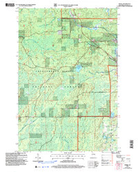
2005 Map of Morse
USGS Topo · Published 2006About this map
The Bad River and its northern tributaries wind through this corner of Ashland County, defining a landscape largely contained within the Chequamegon-Nicolet National Forest. Settlement is concentrated along the Soo Line railroad corridor, where the hamlets of Morse and Cayuga are located. This area represents a quiet intersection of timber management and local history, as evidenced by the Morse Cem and the southern area of Shanagolden.
Find a feature on this map
38 named features on this map. Tap any name to fly to it.
Don’t see what you’re looking for? This feature index may not catch every label — zoom into the map to look around manually.
Map Details
Editions of this 2005 Morse Map
This is the sole edition of this map. No revisions or reprints were ever made.
Other maps of this area

1942 · Glidden
USGS Topo · 1:48,000

1942 · Clam Lake
USGS Topo · 1:48,000

1942 · Mellen
USGS Topo · 1:48,000

1942 · Marengo
USGS Topo · 1:48,000

1945 · Marengo
USGS Topo · 1:48,000

1945 · Clam Lake
USGS Topo · 1:48,000

1945 · Glidden
USGS Topo · 1:48,000

1945 · Mellen
USGS Topo · 1:48,000

1953 · Ashland
USGS Topo · 1:250,000
1956 · Mt. Whittlesey
USGS Topo · 1:24,000