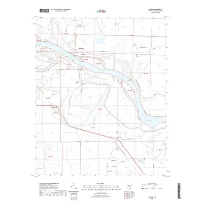
2020 Map of Moscow
USGS Topo · Published 2020About this map
The Arkansas River winds through this Jefferson County landscape, shaping the agriculture and settlement patterns of the region. The river's influence is evident in the prominent meanders of Trulock Bend and Richland Bend, as well as the numerous oxbows and bayous like Noble Lake and Old Channel Plum Bayou that define the low-lying terrain. Historically significant small communities and farm clusters such as Linwood, Moscow, and New Gascony are scattered across the plains, often associated with a density of family and community burial grounds. Genealogy researchers will find an exceptional concentration of cemeteries including Saint Peters Cem, Saint James Cem, Blackman Cem, and New Hope Cem. The presence of Lake Dick in the north and the expansive drainage network of Kings Bayou and Jacks Bayou further illustrate the water-dependent nature of this Delta environment, where roads like Morgan Rd and Atkins Lake Rd navigate the spaces between the wetlands.
Find a feature on this map
59 named features on this map. Tap any name to fly to it.
Don’t see what you’re looking for? This feature index may not catch every label — zoom into the map to look around manually.
Map Details
Editions of this 2020 Moscow Map
This is the sole edition of this map. No revisions or reprints were ever made.
Other maps of this area

1935 · Altheimer
USGS Topo · 1:62,500

1935 · Varner
USGS Topo · 1:62,500

1935 · Noble Lake
USGS Topo · 1:62,500

1941 · Goldman
USGS Topo · 1:62,500

1948 · Helena
USGS Topo · 1:250,000

1950 · Helena
USGS Topo · 1:250,000

1955 · Helena
USGS Topo · 1:250,000

1959 · Helena
USGS Topo · 1:250,000

1960 · Helena
USGS Topo · 1:250,000
1964 · Tarry
USGS Topo · 1:24,000