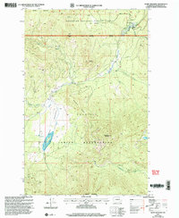
2001 Map of Moses Meadows
USGS Topo · Published 2004About this map
The Colville Indian Reservation and Okanogan National Forest converge in this high-elevation landscape of the Sanpoil and Okanogan country. Dominated by prominent summits like Moses Mountain and Little Moses Mountain, the area is defined by a complex drainage system including the South Fork and Moses Meadows Creek. A clear jurisdictional boundary separates the managed timberlands of the national forest from the reservation lands to the south, marked by the distinctive Mackey Ridge. Small-scale industrial activity is evidenced by a Gravel Pit near the creek, while the presence of named landmarks like Cox Meadow and Granite Mountain suggests a landscape utilized for seasonal grazing and resource management. The map details the transition from the high ridges of Bailey Mountain down to the secluded valleys of Lost Creek and Stepstone Creek.
Find a feature on this map
19 named features on this map. Tap any name to fly to it.
Don’t see what you’re looking for? This feature index may not catch every label — zoom into the map to look around manually.
Map Details
Editions of this 2001 Moses Meadows Map
This is the sole edition of this map. No revisions or reprints were ever made.
Other maps of this area

1902 · Osoyoos
USGS Topo · 1:125,000

1904 · Osoyoos
USGS Topo · 1:125,000

1904 · Republic
USGS Topo · 1:125,000

1951 · Wauconda
USGS Topo · 1:62,500

1952 · Disautel
USGS Topo · 1:62,500

1953 · Bald Knob
USGS Topo · 1:62,500

1954 · Okanogan
USGS Topo · 1:250,000

1957 · Aeneas Valley
USGS Topo · 1:62,500

1958 · Okanogan
USGS Topo · 1:250,000

1958 · Aeneas
USGS Topo · 1:62,500