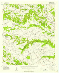
1956 Map of Mosheim
USGS Topo · Published 1957About this map
Norway Mill and the nearby Norway Mill Cem reflect the heritage of Norwegian immigrants who settled this central Texas landscape. In the mid-1950s, the region was defined by a network of rural communities such as Mosheim, Turnersville, and Osage. The topography is marked by significant elevations like Norman Hill and Norway Hill, with numerous waterways including the Middle Bosque River and Coryell Creek dissecting the terrain. The transition of rural education is visible through several marked sites, such as the Hurst Spring Sch (Aband) and Prairie Chapel Sch (Aband), signaling a shift in the local settlement pattern. Transportation and industry are anchored by the Gulf Colorado and Santa Fe River (AT&SF) railroad line in the northeast, supported by infrastructure like the Pendell Pumping Sta.
Find a feature on this map
63 named features on this map. Tap any name to fly to it.
Don’t see what you’re looking for? This feature index may not catch every label — zoom into the map to look around manually.
Map Details
Editions of this 1956 Mosheim Map
This is the sole edition of this map. No revisions or reprints were ever made.
Other maps of this area

1888 · Meridian
USGS Topo · 1:125,000

1892 · Temple
USGS Topo · 1:125,000

1892 · Waco
USGS Topo · 1:125,000

1894 · Meridian
USGS Topo · 1:125,000

1894 · Gatesville
USGS Topo · 1:125,000

1920 · Waco
USGS Topo · 1:125,000

1931 · Whitney
USGS Topo · 1:62,500

1931 · Valley Mills
USGS Topo · 1:62,500

1931 · Mc Gregor
USGS Topo · 1:62,500

1947 · Purmela
USGS Topo · 1:62,500