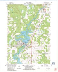
1982 Map of Mosinee
USGS Topo · Published 1982About this map
The Wisconsin River dominates this early 1980s landscape, its waters feeding the Mosinee Flowage and branching around Pine Island. The city of Mosinee is the industrial and civic anchor of the region, featuring a Powerplant, Filtration Plant, and a significant concentration of local history markers including the Mosinee Cem and St Paul Cem. The transition from rural to modern infrastructure is evident in the presence of the Central Wisconsin Airport and the heavy transport corridor of the Chicago Milwaukee St Paul and Pacific Railroad. To the north, the elevation rises toward Rib Mountain, while the surrounding terrain is marked by local industry such as the Quarry in Marathon and several Gravel Pit operations. Smaller rural schools like Evergreen Sch and Boulevard Sch represent the educational landscape of the late twentieth century.
Find a feature on this map
61 named features on this map. Tap any name to fly to it.
Don’t see what you’re looking for? This feature index may not catch every label — zoom into the map to look around manually.
Map Details
Editions of this 1982 Mosinee Map
This is the sole edition of this map. No revisions or reprints were ever made.
Other maps of this area

1899 · Wausau
USGS Topo · 1:125,000

1902 · Wausau
USGS Topo · 1:125,000

1902 · Marathon
USGS Topo · 1:125,000

1953 · Wausau
USGS Topo · 1:48,000

1953 · Marathon
USGS Topo · 1:48,000

1955 · Green Bay
USGS Topo · 1:250,000

1956 · Milladore
USGS Topo · 1:48,000

1956 · Stevens Point
USGS Topo · 1:48,000

1963 · Wausau West
USGS Topo · 1:24,000

1963 · Marathon
USGS Topo · 1:62,500