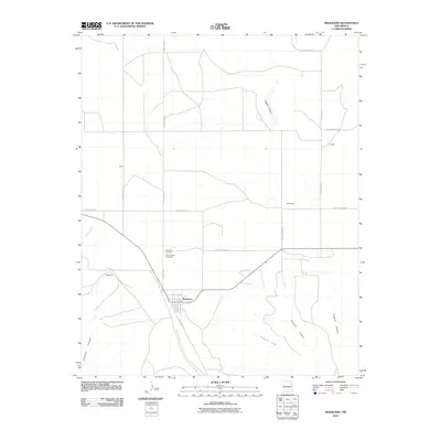
2010 Map of Mosquero
USGS Topo · Published 2010About this map
Mosquero sits at the heart of this high-plains landscape, where the town's street grid contrasts with the sprawling drainage networks of the Canadian River basin. This 2010 survey highlights the rural community infrastructure of Harding and San Miguel counties, most notably the Mosquero Cemetery and Saint Joseph Cemetery located just north of the central settlement. The terrain is defined by dramatic depressions and watercourses, including the steep-walled Fragoso Canyon and Orchard Canyon to the southeast, and the seasonal drainage of Mosquero Creek. Small, isolated locales like Waggoneer, Galey, and McDaniels are linked by a network of county roads, such as County Road O, illustrating the sparse but persistent ranching and agricultural settlement pattern of this region. To the north, the appearance of Black Lake suggests the presence of alkali or playa lake features characteristic of the Llano Estacado's edge.
Find a feature on this map
22 named features on this map. Tap any name to fly to it.
Don’t see what you’re looking for? This feature index may not catch every label — zoom into the map to look around manually.
Map Details
Editions of this 2010 Mosquero Map
This is the sole edition of this map. No revisions or reprints were ever made.
Other maps of this area

1954 · Santa Fe
USGS Topo · 1:250,000

1954 · Tucumcari
USGS Topo · 1:250,000

1958 · Santa Fe
USGS Topo · 1:250,000

1958 · Tucumcari
USGS Topo · 1:250,000

1969 · Salitre Canyon
USGS Topo · 1:24,000

1969 · Chinaberry Canyon
USGS Topo · 1:24,000

1972 · Waggoner Ranch
USGS Topo · 1:24,000

1973 · Mosquero
USGS Topo · 1:24,000

1973 · Sabino
USGS Topo · 1:24,000
1973 · Albert
USGS Topo · 1:24,000