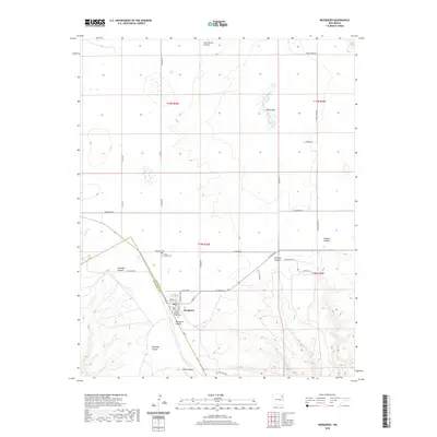
2020 Map of Mosquero
USGS Topo · Published 2020About this map
Mosquero sits at the heart of this high-plains landscape, serving as the seat of local government as indicated by the Harding County Courthouse. The town’s grid is defined by Main St and Lakefront Blvd, while the surrounding territory is deeply incised by a series of drainages, including Mosquero Canyon, Antelope Canyon, and Ensinosa Canyon. These canyons suggest a rugged transition from the flat tablelands toward more complex geological breaks. Evidence of long-standing community roots appears at the Mosquero Cem and the Saint Joseph Cem, both located near the western edge of the town center. The presence of Black Lake and Mosquero Creek highlights the critical role of scarce water sources in this arid region, while the network of county roads like Trujillo Rd and Black Lake Rd connects the isolated ranchlands and canyons that define this part of New Mexico.
Find a feature on this map
40 named features on this map. Tap any name to fly to it.
Don’t see what you’re looking for? This feature index may not catch every label — zoom into the map to look around manually.
Map Details
Editions of this 2020 Mosquero Map
This is the sole edition of this map. No revisions or reprints were ever made.
Other maps of this area

1954 · Santa Fe
USGS Topo · 1:250,000

1954 · Tucumcari
USGS Topo · 1:250,000

1958 · Santa Fe
USGS Topo · 1:250,000

1958 · Tucumcari
USGS Topo · 1:250,000

1969 · Salitre Canyon
USGS Topo · 1:24,000

1969 · Chinaberry Canyon
USGS Topo · 1:24,000

1972 · Waggoner Ranch
USGS Topo · 1:24,000

1973 · Mosquero
USGS Topo · 1:24,000

1973 · Sabino
USGS Topo · 1:24,000
1973 · Albert
USGS Topo · 1:24,000