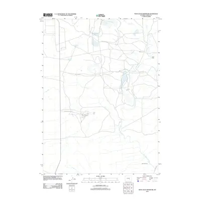
2012 Map of Moss Agate Reservoir
USGS Topo · Published 2012About this map
The Little Medicine Bow River defines the drainage of this Carbon County landscape, winding through a region marked by vital water management and scattered outposts. In the early 21st century, the area near Moss Agate Reservoir and Heward Reservoir remains primarily focused on ranching and resource management, evidenced by the road network branching off Shirley Basin N Rd and Shirley Ridge Rd. The presence of the Walker Homestead and Teton Camp speaks to a history of land use in this high basin. Near the intersection of Shirley Basin Access Rd, a small cluster of streets including Antelope St, Elk, and Badger St suggests a localized pocket of development amid the broader terrain of Chalk Draw and Sand Cr.
Find a feature on this map
19 named features on this map. Tap any name to fly to it.
Don’t see what you’re looking for? This feature index may not catch every label — zoom into the map to look around manually.
Map Details
Editions of this 2012 Moss Agate Reservoir Map
This is the sole edition of this map. No revisions or reprints were ever made.
Other maps of this area

1955 · Casper
USGS Topo · 1:250,000

1958 · Casper
USGS Topo · 1:250,000

1959 · Moss Agate Reservoir
USGS Topo · 1:24,000

1959 · Squaw Spring
USGS Topo · 1:24,000

1959 · Chalk Hills
USGS Topo · 1:24,000

1959 · Bates Creek Reservoir
USGS Topo · 1:24,000

1960 · Mud Springs
USGS Topo · 1:24,000

1960 · Measel Spring Reservoir
USGS Topo · 1:24,000
1961 · Big Charlie Lakes
USGS Topo · 1:24,000
1961 · Cameron Creek
USGS Topo · 1:24,000