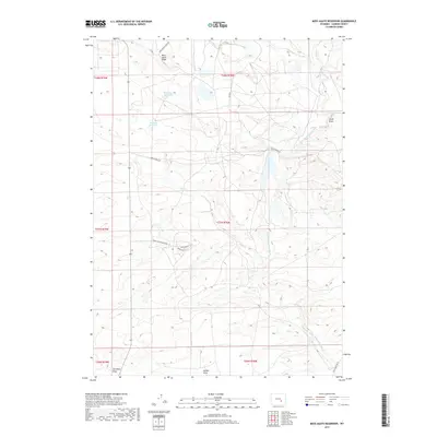
2017 Map of Moss Agate Reservoir
USGS Topo · Published 2017About this map
The Little Medicine Bow River winds through this Carbon County landscape, defining the hydrology of a region where water management is central to the terrain's utility. At the northern edge of the sheet, Moss Agate Ridge overlooks the eponymous Moss Agate Reservoir, while other nearby catchments like Heward Reservoir emphasize the modification of natural drainages for localized needs.
Find a feature on this map
24 named features on this map. Tap any name to fly to it.
Don’t see what you’re looking for? This feature index may not catch every label — zoom into the map to look around manually.
Map Details
Editions of this 2017 Moss Agate Reservoir Map
This is the sole edition of this map. No revisions or reprints were ever made.
Other maps of this area

1955 · Casper
USGS Topo · 1:250,000

1958 · Casper
USGS Topo · 1:250,000

1959 · Moss Agate Reservoir
USGS Topo · 1:24,000

1959 · Squaw Spring
USGS Topo · 1:24,000

1959 · Chalk Hills
USGS Topo · 1:24,000

1959 · Bates Creek Reservoir
USGS Topo · 1:24,000

1960 · Mud Springs
USGS Topo · 1:24,000

1960 · Measel Spring Reservoir
USGS Topo · 1:24,000
1961 · Big Charlie Lakes
USGS Topo · 1:24,000
1961 · Cameron Creek
USGS Topo · 1:24,000