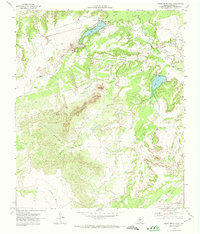
1971 Map of Moss Creek Lake
USGS Topo · Published 1974About this map
Signal Mountains anchor this West Texas landscape, dominated by the peaks of Signal Peak and Signal 2. The industrial character of Howard County in the early 1970s is evident through the extensive Howard Glasscock Oil Field, where numerous Wells and Disposal Wells are situated. Water management is a primary theme of the terrain, with Moss Creek Lake and Powell Lake served by a system of pipelines, an aqueduct, and a Pumping Station.
Find a feature on this map
28 named features on this map. Tap any name to fly to it.
Don’t see what you’re looking for? This feature index may not catch every label — zoom into the map to look around manually.
Map Details
Editions of this 1971 Moss Creek Lake Map
This is the sole edition of this map. No revisions or reprints were ever made.
Other maps of this area

1941 · Big Spring South
USGS Topo · 1:62,500

1942 · Big Spring South
USGS Topo · 1:62,500

1942 · Big Spring North
USGS Topo · 1:62,500

1951 · Iatan
USGS Topo · 1:24,000

1952 · Iatan
USGS Topo · 1:24,000

1954 · Big Spring
USGS Topo · 1:250,000

1954 · Big Spring North
USGS Topo · 1:24,000

1958 · Big Spring
USGS Topo · 1:250,000

1963 · Hayrick Mountain
USGS Topo · 1:24,000
1963 · Hyman
USGS Topo · 1:24,000