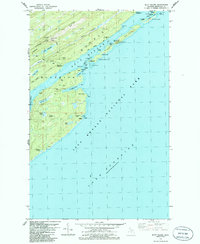
1985 Map of Mott Island
USGS Topo · Published 1986About this map
Greenstone Ridge forms the central spine of this northern island wilderness, where the 1980s landscape reveals a legacy of isolation and copper-era exploration. The park infrastructure is centered at Park Headquarters on Mott Island, providing a focal point for the maritime activity within Rock Harbor. Along the southern shore, evidence of earlier industry is preserved at sites like the Saginaw Mine and Siskowit Mine, while the Caribou Island Light and various beacons point to the navigational hazards of Lake Superior. Interior basins like Lake Ojibway and Sumner L are connected by a primitive network of paths, including the Greenstone Trail and Daisy Farm Trail. This survey also documents remote scientific and residential sites, from the Boreal Research Station on Davidson Island to a lone Grave and Cemetery near the harbor entrance.
Find a feature on this map
63 named features on this map. Tap any name to fly to it.
Don’t see what you’re looking for? This feature index may not catch every label — zoom into the map to look around manually.
Map Details
Editions of this 1985 Mott Island Map
This is the sole edition of this map. No revisions or reprints were ever made.
Other maps of this area

1895 · Passage Island
USGS Topo · 1:62,500

1958 · Hancock
USGS Topo · 1:250,000

1959 · Fort William
USGS Topo · 1:250,000

1960 · Hancock
USGS Topo · 1:250,000

1961 · Hancock
USGS Topo · 1:250,000

1966 · Hancock
USGS Topo · 1:250,000

1968 · Fort William
USGS Topo · 1:250,000

1985 · Todd Harbor
USGS Topo · 1:100,000

1985 · Siskiwit Bay
USGS Topo · 1:100,000
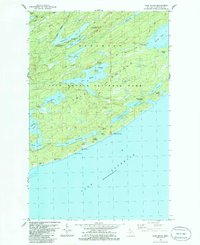
1985 · Lake Richie
USGS Topo · 1:24,000