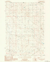
1984 Map of Moulton Creek
USGS Topo · Published 1985About this map
The Little Missouri River flows through this corner of the High Plains, where the border between Montana and Wyoming meets the dividing line of Carter and Crook counties. This 1984 provisional survey illustrates a landscape defined by an intricate network of drainage systems, including the North Fork Little Missouri River and the winding Prong Gammon Creek. The terrain is characterized by broad coulees and intermittent streams that feed into the larger river basin, reflecting the rural ranching character of the region during the early 1980s. High points like Signal Hill overlook a network of unimproved roads and corrals, suggesting a territory utilized primarily for livestock and rangeland. Detailed water features such as Battle Creek and Moulton Creek underscore the importance of water management in this arid stretch of the western frontier.
Find a feature on this map
12 named features on this map. Tap any name to fly to it.
Don’t see what you’re looking for? This feature index may not catch every label — zoom into the map to look around manually.
Map Details
Editions of this 1984 Moulton Creek Map
This is the sole edition of this map. No revisions or reprints were ever made.
Other maps of this area

1905 · Devils Tower
USGS Topo · 1:125,000

1954 · Ekalaka
USGS Topo · 1:250,000

1954 · Gillette
USGS Topo · 1:250,000

1955 · Gillette
USGS Topo · 1:250,000

1956 · Ekalaka
USGS Topo · 1:250,000

1957 · Cedar Ridge
USGS Topo · 1:62,500

1958 · Gillette
USGS Topo · 1:250,000

1958 · Ekalaka
USGS Topo · 1:250,000

1962 · Gillette
USGS Topo · 1:250,000

1965 · Ekalaka
USGS Topo · 1:250,000